High resolution digital terrain model and hyperspectral data cube for Zackenberg
A hyperspectral campaign was carried out over Zackenberg on 7th of August 2000. The Australian HyMap scanner was used by the European project MINEO for scanning of the old mine site in Mestersvig. This made it possible to obtain data from Zackenberg resulting in a high-resolution digital terrain model (DTM) based on aerial photography and a hyperspectral data set from the HyMap sensor.
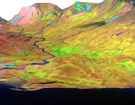
Image showing a HyMap colour composite (band 75, 35, 15 in red, green and blue, respectively) draped on the 4 m resolution DTM.
The campaign was funded by the Danish Research Agency (FNU) and carried out by the Department of Arctic Environment, National Environmental Research Institute (NERI) at Aarhus University and Department of Geography and Geology, University of Copenhagen. These pages are meant as an introduction to the complete data set that was obtained and the products made from the data. All data are made available for research use through this page hosted by NERI and information for the request of data is given below.
The goal of the project was, due to the unique opportunity given, to require the data and make them easy available and ready for research use at Zackenberg Ecological Research Operations.
Area
Only the central part of the area flown in the campaign has been processed for further analysis. This is due to the lack of good ground control points (GCP's) throughout the area. GCP's are necessary to fix an aerotriangulation in space and obtain good absolute accuracy of the DEM. The good GCP's are currently only available in the Zackenberg Valley and the processed area is therefore limited to the area shown in the figure below: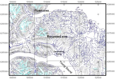
Area overview.
Data from the rest of the flown area is available and can be used for high-resolution digital terrain models and geocoded hyperspectral imagery if good GCP's are established through fieldwork.